Geology
Mission
Direct, coordinate, execute and control compliance with the policy approved by the State and the Government for the increase of geological knowledge in the country.
Guideline 153
Increase and achieve greater effectiveness in geological investigations, with emphasis on those related to mineral resources, geothematic cartography, natural hazards and geological heritage.
"We didn't know anything about geology. The mines owned by American monopolies, when they did their research, only they knew what was there, how much nickel or if there was oil, how much and where, if there was chromium, manganese, whatever. How much rain fell It was known in some places from the rain gauges of some sugar mills. Nobody knew how much water ran here through the rivers, because for that you had to put a water meter there for several years, to see the averages. To build a reservoir, Anyone says that making a reservoir is easy, but you had to first know how much water flowed through that river, where that river could be dammed, what the geology of that supposed reservoir was like, if there were caverns in the subsoil, if it was compact, if it was it filtered the water, if it didn't. And here nothing was known about that, not a word. That is, neither what ran through the rivers, nor where there was a basin, nor what the geology was. "
"Fidel Castro, Plaza de la Revolución, January 2, 1969"
Function
1. Direct the preparation of the proposal of the Geological Investigations Policy of the country, as well as its updating, when necessary, for its presentation to the approval of the Government, by the direction of the ministry. Control your application, once approved.
2. Advise on the preparation of application policy proposals in the Geology sector, for submission to the Government for approval, as well as their periodic updating and implementation, once approved.
3. Advise on the preparation of proposals for the Geology sector development programs in the medium and long term, for presentation to the Government for approval, as well as their periodic updating and control their implementation, once approved.
4. To control the policy of the state and the government regarding the investigation, recognition, prospecting and geological exploration of solid minerals and medicinal mineral waters.
5. Establish jointly with the OACE and related entities, the demands of geological studies for the economic and social development of the country, as well as plan the execution according to the state policy and priority in the short, medium and long term.
6. To dictate annually the plan of the geological activity and the technical tasks, proposed by the Geological Service of Cuba, in coordination with other entities of the country.
7. Execute the analysis of the national balance of resources and reserves to update the geology plans, jointly with the General Directorate of mining, the ONRM, and the Geological Service of Cuba.
8. Advise on the introduction of the results of (R&D) and technological advances in the geology, mining and industry sectors, controlling their inclusion in short, medium and long term plans.
9. Advise the minister and the Government Boards, in the direction and control of the business system linked to geological activity.
10. To rule on the selection of the indicators to evaluate the results of the geological activity in the management of the Business System, periodically controlling their compliance.
11. Control, in coordination with the IGP and ONRM, compliance with the regulations established for geological studies of solid mineral resources and mineral-medicinal waters.
12. To rule on business opportunities with foreign capital, in the field of geology.
13. To dictate, at its level, the draft negotiation directives, related to geology, to establish AEI agreements, for presentation to the approval of the corresponding instance.
14. Control compliance, by the designated negotiating team, of the negotiation directives approved for the constitution of each AEI, related to geology.
15. To rule on the proposals for the Constitutive Documents of the AEI and the economic technical foundation of the business, related to geology, in conjunction with the other areas of the Ministry, as appropriate.
16. Control the results of AEI related to geology, in operation. Participate in the elaboration of the directives of the Cuban side, to be evaluated in the Boards of Directors and Shareholders that ensure compliance with state policy.
17. To rule on the requests for extension and dissolution of the AEI constituted, related to geology.
18. Control the rational use of foreign technical assistance used in geology.
19. Participate in the preparation of policy proposals and strategies for collaboration and technical scientific cooperation of geological activity.
20. Participate in the control of compliance with the collaboration programs of the branch or activity it serves, signed with countries and International Institutions.
21. Establish the investment strategy in geological activity in coordination with all related entities and agencies.
22. To rule on proposals of the Investment Plans in the short and medium term related to geological activity.
23. Control the process for investment in the Geology of the Business System, particularly investments financed by the State.
24. Decide if the objectives were met, for which the investments were conceived, once started.
25. Advise and control the strategic projection in the geology sector for the development of quality systems, environmental management, introduction of technologies and research in the country.
26. Judge and propose geological research projects (R + D + i) for the country, controlling their compliance, once approved.
27. Control the application of mechanisms to certify the quality of projects financed by the Geological Service of Cuba.
28. Coordinate and control the exchange of the necessary geological information with other MINEM directorates, other agencies and entities.
29. Promote the export of geological services, and geological studies that can constitute an exportable fund.
30. Periodically advise the Government on the substitution of imports for the use of Cuban rocks and minerals.
31. Direct the carrying out of inspections within the scope of its competence.
32. Control the costs and expenses of geological studies in conjunction with specialized entities in the country.
33. Participate in the proposal, management and approval of the state budget linked to the program for geological development, in the short, medium and long term.
34. Coordinate and control the updating and application of procedures, regulations and standards for the technical-economic control of geological works in the country.
35. Advise the IGP and the ONRM, in their functions related to geological activity.
36. Advise the Directorate of the Ministry, participating in the preparation and analysis of proposals for legal provisions, rules and regulations of the branches or activities within its competence.
37. Attend, at the request of the Ministry's management, technical-production agreements, work plans and protocols, preparing evaluative reports with recommendations for decision-making at the corresponding level, related to matters within its competence.
38. Promote relations between the Ministry and national and foreign organizations, as decided.
Directory
DIRECTOR: Enrique A. Castellanos Abella
EMAIL: castellanos@minem.gob.cu
PHONE: (+53) 78775038
SPECIALIST: Rosa Maria Cobas Botey
EMAIL: rcobas@minem.gob.cu
PHONE: (+53) 78775091
SPECIALIST: Emet Dominguez López
EMAIL: emet@minem.gob.cu
PHONE: (+53) 78775091
SPECIALIST: Alina Rodríguez García
EMAIL: alina@minem.gob.cu
PHONE: (+53) 78775164
DOCUMENT MANAGEMENT: Talia Martinez Cuni
EMAIL: talia@minem.gob.cu
PHONE: (+53) 78775038
Development Lines
MAIN LINES OF DEVELOPMENT OF GEOLOGICAL ACTIVITY
Characteristics of the geological activity and the geology system Main lines of development
- Complete and update the Geological Map of Cuba, at different scales and in different formats and supports, as a cartographic expression of the geological knowledge of the country.
- Complete and keep updated the Stratigraphic Lexicon of Cuba, consisting of the description of all the lithostratigraphic units that can be mapped on the surface and in the subsoil of the national territory.
- Promote the development of geophysical investigations, as a basic support for geological investigations.
- Increase the resources and reserves of metallic and non-metallic minerals, for national use and thus increase exportable funds and import substitution. Strengthen these studies to promote local development.
- Increase hydrocarbon resources and reserves to contribute to the country's energy development and to achieve its energy security.
- Interpret the links and incidence of geological processes on human health to favor the reduction of their negative effects.
- Expand knowledge about renewable energy sources related to Geological Sciences, such as geothermal and hydraulic energy, among others.
- Develop hydrogeological knowledge about the conditions under which groundwater is captured, migrated and distributed, necessary for the economy and society, as well as expanding knowledge about mineral-medicinal waters, contributing to its characterization and inventory.
- Increase, specifically, the knowledge of the karst territories and their superficial and underground forms, given that sixty percent of the national territory is made up of carbonate rocks.
- Provide knowledge for the preparation of Engineering-Geological Maps and the engineering-geological characterization of the different types of rocks, for their use as construction materials and to develop infrastructure in them, including underground.
- Generate knowledge about natural hazards, particularly geological ones, study their processes and determine the natural vulnerabilities associated with them for proper risk management and thereby contribute to disaster reduction. Give special attention to the coastal area and the marine platform.
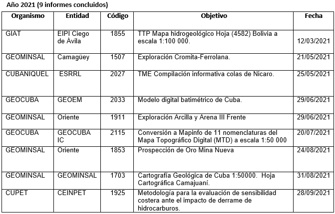
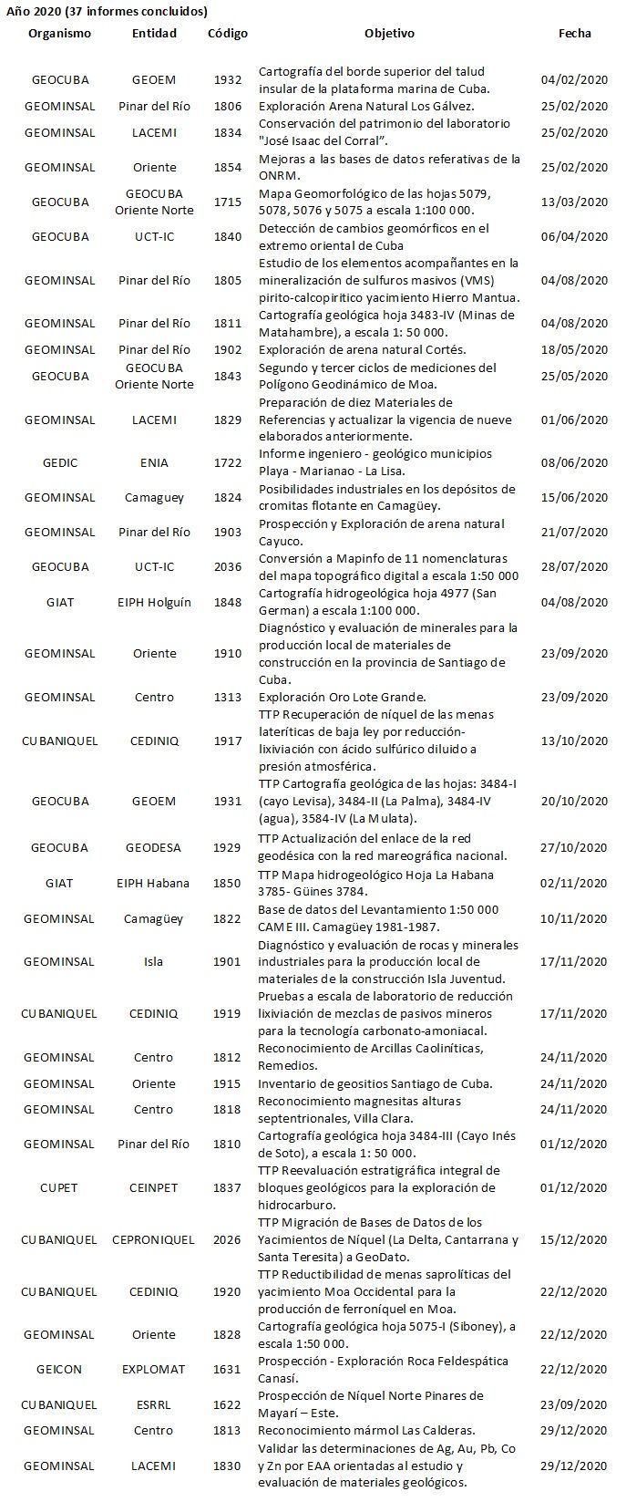
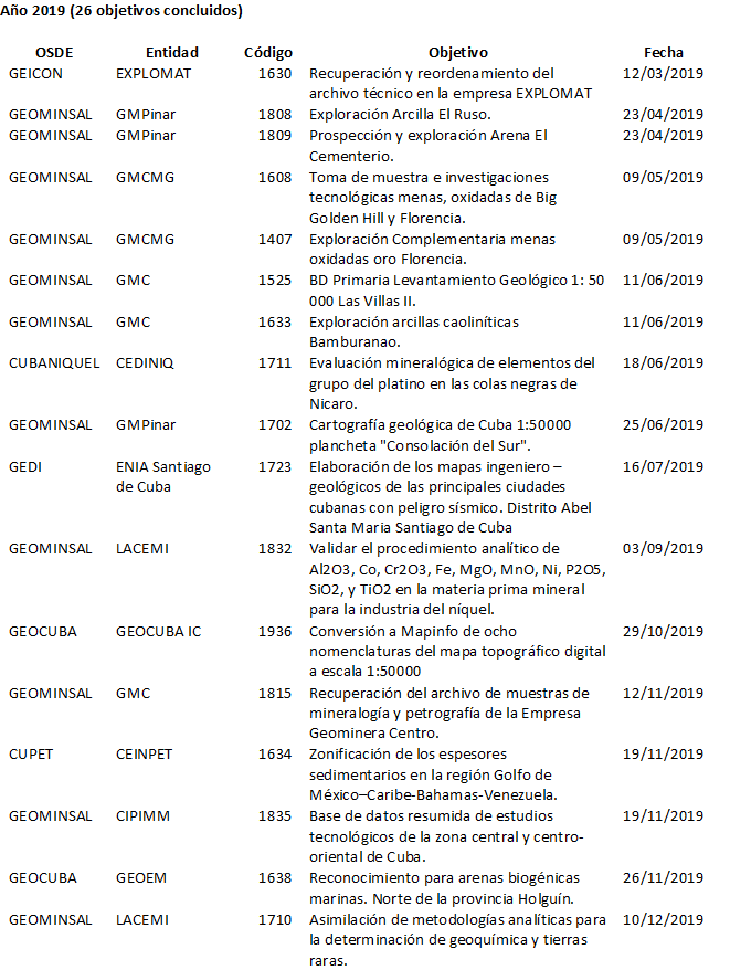
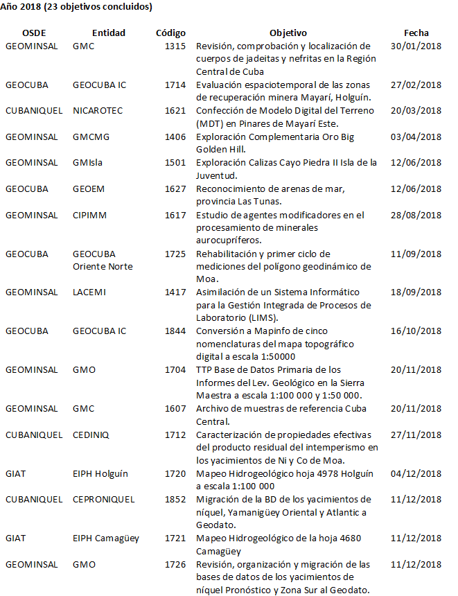
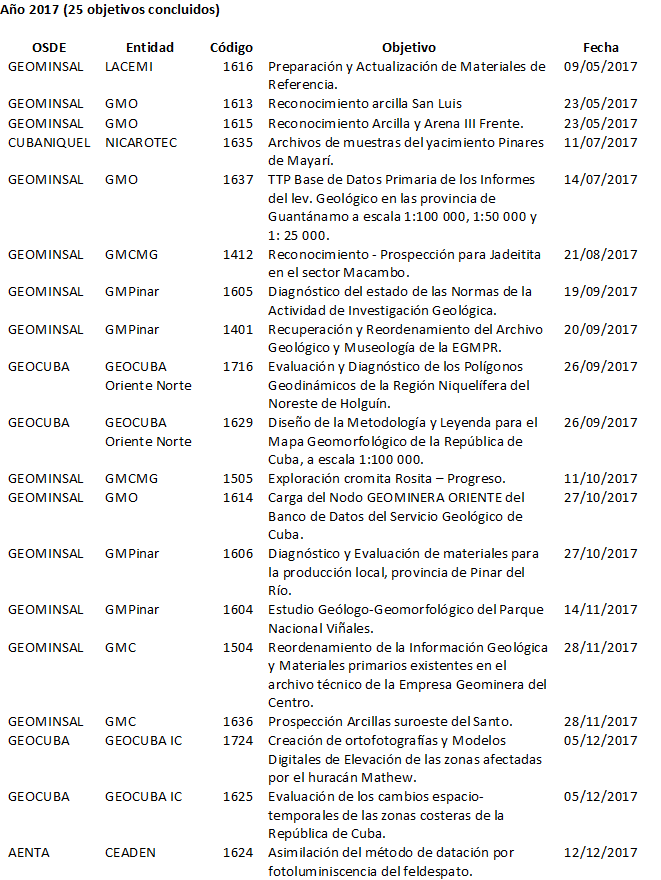
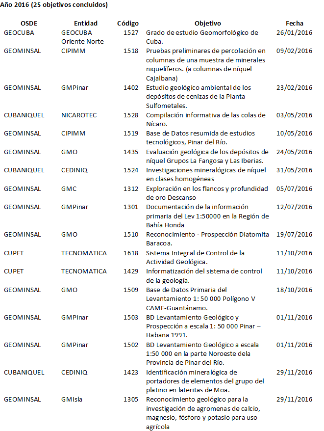
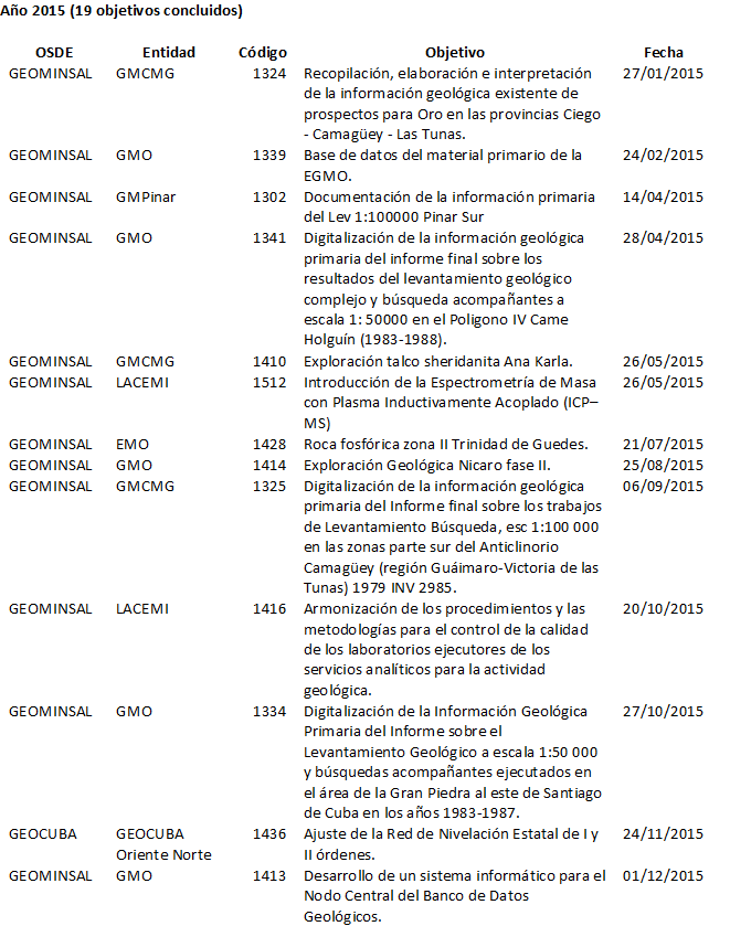
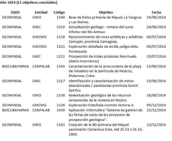
Reports Concluded
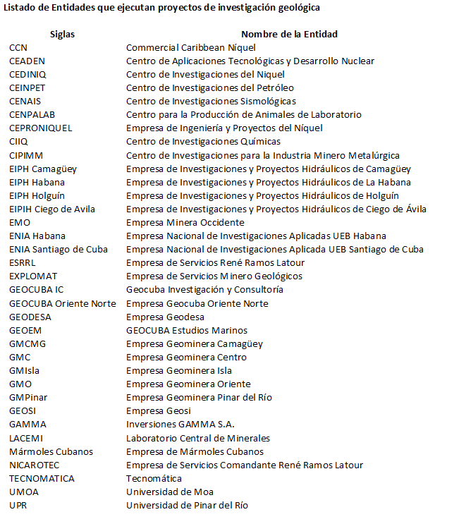
In Cuba, a group of geological investigations of state interest are financed with the State Budget. The geological reports of the investigations completed by year are listed below.
These reports, both printed and in digital format, are stored in the Institute of Geology and Paleontology - Geological Service of Cuba (www.igp.minem.cu) and those related to mineral resources are also stored in the National Resources Office. Mining (www.onrm.minem.cu). These documents can be consulted free of charge at both institutions. At the end, the acronyms of the entities that carry out these investigations are listed.
Legal Norms on Geological Research and Geological Survey
LEGAL STANDARDS APPROVED IN THE GEOLOGY POLICY
This package of regulations was published in the Official Gazette of the Republic of Cuba No. 41 of August 17, 2018 which can be downloaded HERE.
The standards contained in this package are:
- Decree 345, “On the geological research activity and the Geological Service of Cuba”.
- Resolution No. 124 of the MINEM, to approve the "Manual of instructions for geological research activity".
- Resolution No. 125 of the MINEM, to approve the "Organization and operation of the National Geological Information System, the general bases on the generation, dissemination, access, use and preservation of geological information and relations with the Institute of Physical Planning."
- Resolution No. 126 of the MINEM, to approve the "Regulations of the National Geology Council".
- Resolution No. 127 of the MINEM, to approve the “Regulation of the Commission of the Stratigraphic Lexicon of Cuba”.
- Resolution No. 128 of the MINEM, to approve "the organizational bases for the operation of the Geological Data Bank of Cuba."
- Resolution No. 229 of the MFP, to approve "updating the geological compensation rate."
The content of each standard is briefly explained below. A brochure with a summary of each standard can be downloaded HERE
Decree 345 "On the geological research activity and the Geological Service of Cuba"
- It establishes the principles that govern the operation of the geological research activity and the Geological Survey of Cuba, given its interest for the nation.
- It defines that the activity is regulated by an Instructions Manual approved by the MINEM (Res 124).
- It specifies that the activity is governed by the medium and long-term Development Program, in correspondence with the country's economic and social development program.
- Declares the geological information generated as the main element for increasing geological knowledge and specifies aspects related to it (Res 125).
- Defines the main aspects of geological cartography (geological maps) in the country.
- It formulates that the strategy of geological studies on mineral resources is defined in the Development Program.
- Creates the National Geology Council (Res 126) made up of 12 national agencies and entities for the coordination of geological studies in the country.
- It defines that the Institute of Geology and Paleontology (IGP) represents the Geological Service of Cuba, is in charge of increasing geological knowledge and details the activities carried out by the IGP.
- It explains that the IGP, in turn, conducts scientific research and contracts geological work from other entities, financed from the State Budget.
- Creates the Commission of the Stratigraphic Lexicon of Cuba, as an organ of the IGP (Res 127) to keep updated and approve the Cuban Code of Stratigraphy and Stratigraphic Lexicon of Cuba.
- It establishes that the Geological Data Bank is an organizational unit of the IGP (Res 128) in charge of keeping the main databases of the activity updated.
- It defines that those who exploit mineral resources pay the State Budget a compensation rate (Res 229) for the geological research work carried out.
- It specifies that geological investigations that respond to state interests are financed fundamentally with the State Budget.
- It establishes that the Minister of Energy and Mines decides the priorities and needs and approves the plan for geological objectives every year.
Resolution No. 124 of the MINEM, to approve the "Manual of instructions of the geological investigation activity"
The Activity Instructions Manual consists of 8 instructions:
IAG 01 General instruction.
IAG 02 On the types of geological projects.
IAG 03 Preparation and approval of the Technical Task.
IAG 04 Preparation of projects.
IAG 05 Reporting.
IAG 06 Evaluation and approval of projects and reports.
IAG 07 Control of geological research activity.
IAG 08 About the project manager.
Each instruction has a different scope, but they all apply to state-funded projects.

Resolution No. 125 of the MINEM, to approve the "Organization and operation of the National Geological Information System, the general bases on the generation, dissemination, access, use and preservation of geological information and relations with the Institute of Physical Planning."
- It establishes the organization and operation of the National Geological Information System, determining who is part of it and what objectives it has.
- It defines the main elements of the generation, dissemination, access, use and preservation of geological information.
- It specifies the relations with the Physical Planning Institute regarding the geological information that is required for territorial planning and for the investment process.
Resolution No. 126 of the MINEM, to approve the "Regulations of the National Geology Council".
- It establishes the organization and operation of the National Council of Geology, which will meet twice a year in ordinary session, chaired by the Minister of Energy and Mines.
- It defines the common powers and obligations of the president, vice president and secretary of the National Council of Geology.

Resolution No. 127 of the MINEM, to approve the “Regulation of the Commission of the Stratigraphic Lexicon of Cuba”.
- Establishes the functions and structure of the Lexicon Commission (Board of Directors and subcommittees).
- It details the operation of the Lexicon Commission.
- It specifies the powers and obligations of the members of the Lexicon Commission.
The Cuban Code of Stratigraphy establishes the procedures and principles that define and name the stratigraphic units, understood as bodies of rocks in a natural state, which are distinguished from adjacent rocks.
The Stratigraphic Lexicon of Cuba compiles, for the purposes of its official recognition, the stratigraphic units located both on the surface and in the subsoil, and includes their characteristics.
Resolution No. 128 of the MINEM, to approve "the organizational bases for the operation of the Geological Data Bank of Cuba."
- It defines the administration of geological data by the data bank, which is applicable to the collection, conservation and use of the same.
- Establish the origin of the geological data in Annex.
- It details the functions of the data bank.
- Specifies that the Data Bank groups the terms, code lists and nomenclators used in the branches of geology.
- It establishes the obligation to supply geological data to the Data Bank, without prejudice to what is regulated for its protection and self-support.
- It is defined how to guarantee the conservation of the stored data.
- It is available on the access and use of the geological data contained in the Data Bank, and in the territorial and specialized data banks.
Resolution No. 229 of the MFP, to approve "updating the geological compensation rate."
- Updates the geological compensation rate that must be paid by holders of the right to exploit crude oil fields (5.11 CUP / t) and nickel fields (24.75 USD / t), for past works financed by the State.
- Defines that this payment must be made monthly.
- This resolution only binds CUPET and CUBANIQUEL.
Geological compensation rate

Legal Norms on Geological Heritage
LEGAL STANDARDS APPROVED IN THE GEOLOGY POLICY
This package of regulations was published in the Ordinary Official Gazette of the Republic of Cuba No. 69 of October 8, 2020 which can be downloaded HERE.
The standards contained in this package are:
- Decree 11, “On the Geological Heritage of Cuba”.
- Resolution No. 81 of the MINEM, on "Issue the conformity to export geological samples and mineral concentrates."
- Resolution No. 82 of the MINEM, to "Evaluate and declare geosites, rule and propose geoparks and establish the principles of conservation of geosites and geological samples."
Decree 11, “On the Geological Heritage of Cuba”.
- It establishes the legal framework for geosites, geoparks and geological samples, for their identification, proposal, declaration, use, conservation and control.
- Define what is geological heritage, geosite, geopark, geological sample, geodiversity and geoconservation.
- It holds MINEM responsible for directing and controlling activities related to the Cuban geological heritage and establishes the functions that it must fulfill for this purpose.
- It is responsible for the Institute of Geology and Paleontology (IGP) - Cuban Geological Service with (creating and) keeping the inventory of geosites and geoparks updated.
- Creates the National Geoparks Committee and defines its functions.
- Defines the protection of geological samples
Resolution No. 81 of the MINEM, on "Issue the conformity to export geological samples and mineral concentrates."
- Authorizes the Director General of the National Office of Mineral Resources (ONRM) to issue approval for the export of geological samples and mineral concentrates, which have no commercial interest, with the aim of submitting them to studies and investigations.
- It can be requested by any natural or legal person.
- Precious metals or precious stones also require authorization from the Central Bank of Cuba.
- Soil and fossil for DNA analysis, it also requires authorization from CITMA.
Resolution No. 82 of the MINEM, to "Evaluate and declare geosites, rule and propose geoparks and establish the principles of conservation of geosites and geological samples."
Geosites

- It designates the IGP to evaluate and declare that a natural site meets the technical requirements to be considered a geosite and to determine and propose that an area of the national territory has a geological heritage with sufficient value to be a national geopark.
- It can be proposed by any natural or legal person, with a file defined in an annex.
- The geosite was declared by resolution of the Minister of Energy and Mines and published in the Official Gazette.
- The declaration is non-binding and uses and other potential declarations (tourism, heritage and protected areas) are proposed.
Geoparks
- Appoints the IGP to analyze and issue an opinion on a geopark proposal.
- It can be proposed by any natural or legal person, with a file defined in an annex.
- The National Geoparks Committee participates with the functions it has established in the Decree.
- The Minister of Energy and Mines proposes it as a zone of special regulations.
- He explains how to propose that a National Geopark can become a UNESCO World Geopark.
- Defines the principles of conservation of geosites and geological samples.
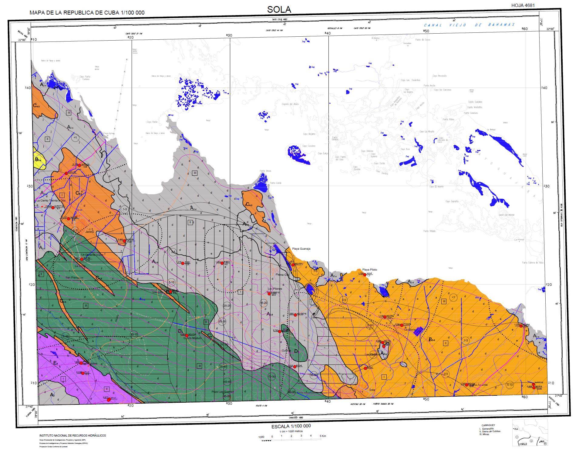
Geological Map of Cuba
Geological Map of Cuba at 1:50 000 scale.
A geological map is the representation on a topographic plane of the geology that emerges on the earth's surface. The different rocks or geological formations and their ages are represented by a grid of colors that identify them. The geological map also represents, with specific symbols, rock deformations such as faults, folds or foliations.
Geological maps have multiple applications: for the study of mineral resources including energy and groundwater, for the design and execution of pipelines (roads, railway lines, oil pipelines, water channels and others), for the construction of reservoirs and other engineering works. They are also used for territorial and urban planning, as well as for studies of geological hazards, environmental geology and pollution. Therefore, this type of map is basic for the economic development of nations.
In 2017, the sub-program for the realization of the Geological Map of Cuba at 1:50 000 scale began, which is made in 420 sheets with its accompanying text. The area of the map corresponding to the emerged part of the national territory is made by the Geomining companies of the Geominsal Business Group and the submerged part, by the Geocuba Marine Studies Company of the Geocuba Business Group.
The map run coverage by sheets is as shown below:

The sheets ending with a hyperlink in jpg are listed below. To obtain the complete sheet and the accompanying text, you should contact the Geological Survey of Cuba:
Finished sheets:
Geomorphological Map of Cuba
Geomorphological map of Cuba at a scale of 1: 100 000.
The geomorphological map represents, through patterns, colors and symbols, the characteristics and evolution of the relief of an area. It is used in both emerged and submerged areas and explains the chemical, physical and biological processes that operate on the Earth's surface to interpret the types of landscapes and landforms.
Geomorphological maps are widely used for the study of current surface processes, such as those related to natural hazards (floods, landslides and earthquakes, among others). They are also used for territorial planning, river basin management, soil studies for agriculture, environmental studies, those related to pollution and engineering work where it is necessary to consider erosive and cumulative processes, among other uses.
In 2016, the sub-program for the realization of the Geomorphological Map of Cuba at 1: 100 000 scale began, which is made in 120 sheets. The work on this map is carried out by the Geocuba Oriente Norte Company of the Geocuba Business Group.
The map execution coverage by sheets is as shown in the following figure:

The sheets ending with a hyperlink in jpg are listed below. To obtain the complete sheet and the accompanying text, you should contact the Geological Survey of Cuba:
Finished sheets:
Geosites
As part of the implementation of the Legal Norms of Geological Heritage, the geosite declaration process began in Cuba. Initially, the geosites that are inventoried by the Cuban Geological Survey in the provinces will be declared and then the declarations of any geosite or groups of these that are proposed by any natural or legal person will begin.
The geosite declaration resolutions are listed below in order of publication:
1.Geosites of the province of Pinar del Río
Resolution 87/21 (GOC-2021-217-O25)
2.Geosites of the province of Artemisa
Resolution 199/21 (GOC-2021-747-O89)

3.Geosites of the province of Mayabeque
Resolution 200/21 (GOC-2021-747-O89)

4.Geosites of the province of Havana
Resolution 209/21 (GOC-2021-800-O95)
Geological Policy
POLICY FOR THE IMPROVEMENT OF THE GEOLOGICAL RESEARCH ACTIVITY AND THE IMPLEMENTATION OF THE CUBA GEOLOGICAL SERVICE
The "Policy for the improvement of the geological research activity and the implementation of the Geological Survey of Cuba", approved on March 1 by the Council of Ministers, is the result of work carried out over eight months by 37 colleagues out of 13 Organisms of the Central State Administration (OACE).
It defines key aspects for the development of geological activity in the country and approves an implementation schedule to be executed in the coming months, which includes the legal instrumentation of the approved aspects and a set of specific actions aimed at solving the problems detected during the diagnosis carried out, as the first stage of the elaboration of the policy proposal.
An extract of the document approved by the Council of Ministers is presented below, including, in italics, comments on the approved aspects.
General Objective of the Policy:
Generate and provide, in a systematic way, geological knowledge of the national territory in order to:
- Increase the resources and reserves of mineral raw materials that the productive sector demands;
- contribute to the efficient use of mineral resources;
- provide the geological knowledge required by other sectors of the economy and society;
- minimize environmental impacts and the incidence of geological processes on human health, and
- preserve the geological heritage of the country.
See more in acapite Policy, Projects and Programs
Hydrogeological Map of Cuba
Hydrogeological Map of Cuba at 1: 100 000 scale.
The hydrogeological map represents the origin, circulation and dynamics, geological conditions and interaction with soils and rocks of the groundwater. It explains its main physical, chemical and biological properties, as well as the conditions that determine the measures aimed at its use, regulation and capture.
Hydrogeological maps make it possible to define perspective aquifer horizons and to know the conditions under which their waters can be used. Recognize their distribution and movement through different rock strata or geological fault zones. It describes the processes of saline intrusion by seawater or by layers of rocks with high content of salts, allowing the development of strategies to reduce their impact. The perspective areas that are defined can be linked to the supply needs for existing or planned objectives in the territory. In this way, it is a basic tool for the use and exploitation of groundwater in economic and social development.
Groundwater, due to different phenomena, such as climate change and exploitation itself, changes its parameters over time, which is why hydrogeological maps require updating.
In 2017 the execution of the sub-program for the realization of the Hydrogeological Map of Cuba at 1: 100 000 scale began, which is made up of 97 sheets. The work on this map is carried out by the companies of the Terrestrial Water Management Business Group (GIAT) of the National Institute of Hydraulic Resources:
The map execution coverage by sheets is as shown in the following figure:

The sheets ending with a hyperlink in jpg are listed below. To obtain the complete sheet and the accompanying text, you should contact the Geological Survey of Cuba:
Finished sheets: